Pekoe Trail
- Home
- Pekoe Trail
STAGE IS OPEN - signage is available, and trail conditions are regularly monitored.
Put on your hiking boots for the inaugural stage of The Pekoe Trail, which stretches from Hanthana to Galaha. Start your journey at the Ceylon Tea Museum—an excellent spot for those interested in Sri Lanka's tea history—and stroll under the shade of the towering trees along the Hanthana Tea Estate, one of the island's oldest and largest tea plantations.
| Distance | 12.8 km |
|---|---|
| Difficulty | Easy |
| Elevation Gain | 458 m |
| Elevation Loss | 410 m |
| Max Elevation | 1,067 m |
As you trek alongside the rocky ridge of 'Katusu Konda' (Lizard’s Back in Sinhala), enjoy stunning views of the seven peaks of the Hanthana range and the nearby Knuckles mountain range. On a clear day, you may even spot parts of the Victoria Reservoir. Keep an eye out for various birds, including black eagles soaring over the higher elevations.
You'll also pass a striking mountain face featured in ‘Indiana Jones and the Temple of Doom,’ which was filmed in Kandy and the Hanthana area by director Steven Spielberg in 1983.
Throughout the trail, you’ll encounter smaller villages, including Kithulmulla, where you can sample some of the best avocados. This community marks the end of Stage 1, close to the post office in Galaha.

THE STAGE IS OPEN – signage is displayed, and trail conditions are being actively monitored.
Today's hike features one of the briefest and most beloved segments of The Pekoe Trail.
This section starts in the charming hill-country town of Ella, a favorite spot for travelers looking to explore tea plantations, immerse themselves in nature, and relax. You'll trek through the Ella Forest Reserve, passing by the iconic Nine Arches Bridge, where you'll likely encounter other hikers and visitors taking pictures. The trail also weaves through quaint local villages, offering breathtaking views of the Nine Arches Bridge from various angles.
| Distance | 8.74 km |
|---|---|
| Difficulty | Easy |
| Elevation Gain | 393 m |
| Elevation Loss | 524 m |
| Max Elevation | 1,066 m |
Ascend along additional village roads toward the Newburgh Tea Factory, navigating through chena cultivations, tea estates, railway tracks, and a picturesque small lake. A key highlight of this segment is the Demodara Tea Estate, enveloped by scenic tea trails. The journey concludes at one of the most picturesque train stations in the hill country: the Demodara train station. This station is renowned for its spiral rail line, known as the 'Demodara Loop,' which circles beneath itself, traversing a tunnel that runs directly underneath the railway station.

THE STAGE IS OPEN – signage is displayed, and trail conditions are being actively monitored.
This is a calf-stretching hike divided into two sections: the first shorter trail takes you from Galaha to Deltota and the second from Deltota to Loolkandura.
Begin your journey at Galaha, a charming town nestled in the hills of the central highlands. Walk through the beautiful Deltota Estate on estate roads, past an old kovil, and over mountains. Prepare yourself for lots of twists and turns as you approach Deltota, a typical hill country town with a lively market that serves as a wonderful pit stop to fuel up on snacks of local fruits.
| Distance | 14.7 km |
|---|---|
| Difficulty | Difficult |
| Elevation Gain | 853 m |
| Elevation Loss | 520 m |
| Max Elevation | 1,402 m |
Starting from Deltota, you'll stroll beneath the shade of towering pine trees, but be wary of leeches, particularly during the rainy season.
The trail leads past Loolkandura Estate, the first tea plantation in Sri Lanka, founded in 1867 by Scotsman James Taylor, who is often called the 'father of Ceylon tea.' Proceed along the tea trails, where you'll navigate through stunning tea bushes that offer views of a large rock formation and tropical rainforests. The segment concludes in Loolkandura.
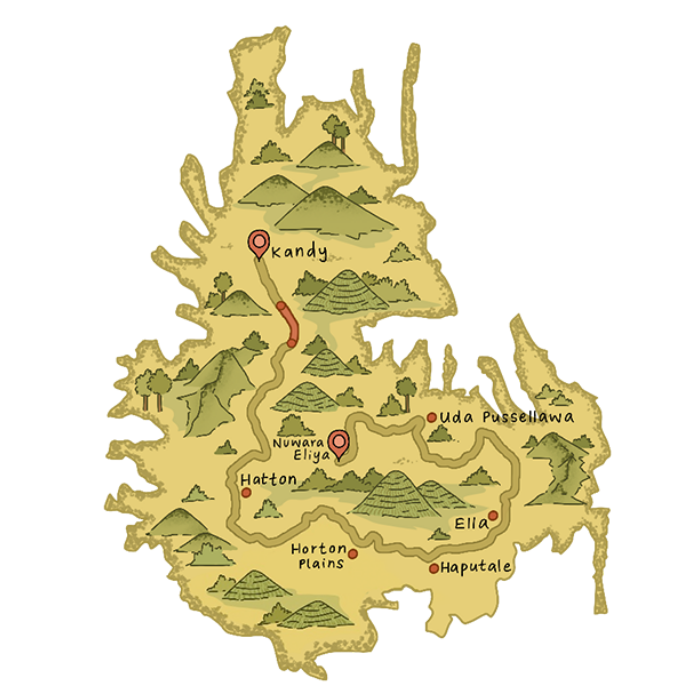
| Length | 14.9 km (9.3 mi) |
|---|---|
| Average Duration | 4 hours 30 minutes |
| People Interactions | High |
| Region | Hatton |
| Elevation Gain | 523m (1,716 ft) |
| Elevation Loss | 627m (2,057 ft) |
| Maximum Elevation | 1364m (4,475 ft) |
Starting at the Watagoda Train Station, take a left turn across the railway line and follow a street flanked by modest homes and a volleyball ground on your right.
At the 0.3 km point, the path transforms into a dyke separating two lakes—one large, the other smaller. Shortly after, you’ll encounter a magnificent Hindu Kovil on your right, adorned with intricate carvings and a striking wooden door.
At the 1.3 km point, the trail meanders downhill, zig-zagging through the terrain. Here, a majestic banyan tree and a serene stream create a picturesque spot. The path continues for several hundred meters until it reaches the railway line. Turn left and walk along the tracks for 75 meters, where a trail branches off to your right.
The next 1.7 km offers a classic tea trail experience with mostly flat terrain through the Holyrood Estate. At the 3.7 km mark, you’ll arrive at the estate’s main bungalow. A charming sign on the warehouse façade reads, “Did you hug a tree today?”—a sentiment you’ll likely embrace on this journey.
Descending 100 meters in elevation, the trail leads to the estate’s impressive tea factory. After passing through the factory grounds, exit via a wide-open gate, turn left, and follow a tarmac road for 200 meters. Along the way, admire vibrant street art on a retaining wall—evidence of the region’s talented artists.
At the 5.25 km point, take a sharp left up a side street as the Pekoe Trail leaves the main road. After passing through a small village, the trail re-enters tea country. At the 5.6 km mark, cross the railway line for the third time and continue along the main road toward Thalawakele town.
After crossing the bridge into Thalawakele, the heart of the Dimbula tea district situated at an elevation of 1,198 meters with a pleasant average temperature of 18°C, this bustling transport hub offers a glimpse of Sri Lankan life amid stunning tea landscapes. Upon crossing the bridge, turn right over the railway line and walk along the platform. A short stairway leads to the Hatton-Talawakele Road. After a brief roadside walk, cross over and ascend into the Talawakele Estate.
Once you leave Thalawakele, the trail becomes enchanting, weaving through valleys and connecting small hamlets. This stretch feels like stepping into a fairy tale, reminiscent of “The Shire” in The Lord of the Rings. The ascent is gentle, leading to the St. Clair Tea Factory at the 9 km mark, which boasts its own train station. Pause to visit the factory or sip fresh tea. From here, a village track leads to views of St. Clair’s Falls, also known as “Little Niagara of Sri Lanka,” one of the country’s widest and most stunning waterfalls.
Shortly after, the trail zig-zags upward through manicured tea hills, offering magnificent views of the Kotmale Valley below, with the contours of the Nanu Oya River visible in the distance.
At the 12 km point, the trail reaches a small village within the Derryclaire Estate. Beyond this, a final hill and a stretch of shaded forest await.
At the 15.3 km point, the trail briefly joins the Talawakele-Hatton road at Kotagala, marked by a vividly painted Hindu Kovil. Kotagala serves as a convenient endpoint with a train station, tuk-tuks, and shops for restocking supplies. This marks the conclusion of the 6th stage of the trail, a journey filled with captivating scenery and cultural landmarks.
Responsible interaction with the environment to avoid depletion or degradation of natural resources and allow for long-term environmental quality.

| Length | 16.48 km (10.24 mi) |
|---|---|
| Average Duration | 5 hours |
| People Interactions | High |
| Region | Hatton |
| Elevation Gain | 513m (1,683 ft) |
| Elevation Loss | 614m (2,014 ft) |
| Maximum Elevation | 384m (4,541 ft) |
This stage begins in the town of Kotagala, marked by a vividly painted Hindu Kovil that serves as a prominent landmark. The trail veers to the left, following a straight road that skirts the outskirts of Kotagala. Entering the Drayton Estate, the path passes by the old tea factory, immersing you in the region’s rich tea heritage.
At the 2.3 km mark, the trail reaches Chrysler’s Farm Tea Factory. Shortly after, it crosses a small bridge before turning left. The roads here are wide and relatively flat, making for an easy kilometer of walking. At the 3.3 km mark, you cross the train line and begin ascending toward the day’s third and final hill. This section feels more secluded, offering a tranquil contrast to earlier parts of the trail. At the 4.7 km point, the hilltop reveals stunning views of Hatton town below.
At 5.9 km, the trail crosses the train line again, turns left near a tea shed, and traverses a small creek leading to tea fields. By 6.3 km, you’ll arrive at Singamalai Lake, a vital water source for Hatton and nearby villages. This serene spot is perfect for a picnic and a well-earned break.
The following 5 km wind through rolling green tea hills, gradually unveiling the first glimpses of the Castlereagh Reservoir in the Bogawantalawa Valley, known as the “golden bowl” of Sri Lanka’s finest tea.
At the 7.8 km mark, a football ground appears to the left—a testament to the sport’s popularity in tea country, perhaps more so than in other rural regions of Sri Lanka.
By 9 km, as you crest a hill, the Battalgalla Tea Factory comes into view alongside the distinctive red roof of the Dickoya & Maskeliya Cricket Club (DMCC), affectionately called The Darrawella Club. Renowned as one of Sri Lanka’s premier planters’ clubs, a visit here is highly recommended.
At 9.4 km, the trail briefly merges with the Agarapatana-Dick Oya road for about 400 meters before veering left near the planters’ club. Shortly afterward, the path crosses the Dick Oya River and ascends through a small hamlet, winding its way toward the next valley.
This stretch of the trail feels elevated, traversing the tops and sides of valleys. Christian churches dot the landscape here, reflecting the predominantly Tamil community, which practices Christianity and Hinduism. You might even encounter Father Alexander, the local pastor, who provides spiritual guidance and serves as a counselor to his congregation.
Brightly colored line rooms—terraced housing for tea workers—populate this region. Some are single lines, while others form larger villages complete with Hindu Kovils and Christian churches, offering a vibrant glimpse into the lives of tea estate workers.
At 12.1 km, the Castlereagh Reservoir comes into full view as the trail descends toward the valley below. Meandering through tea estate paths, you’ll encounter shortcut options for the fit and adventurous or more gradual routes for those who prefer a leisurely pace.
At the base of the valley lies Norwood, a lively tea town. The bridge at the 15 km mark signals your arrival at the town’s edge. The stage officially concludes 600 meters further into Norwood, offering a well-deserved rest in this bustling hub of Sri Lanka’s tea country.
Responsible interaction with the environment to avoid depletion or degradation of natural resources and allow for long-term environmental quality.

| Length | 15.93 km (9.89 mi) |
|---|---|
| Average Duration | 4 hours 30 minutes |
| People Interactions | Low |
| Region | Hatton |
| Elevation Gain | 562m (1,844 ft) |
| Elevation Loss | 377m (1,237 ft) |
| Maximum Elevation | 1543m (5,062 ft) |
Norwood marks the gateway to the Bogawantalawa Valley, a crucial crossroads for those venturing deep into Sri Lanka’s tea country. It connects Hatton to Maskeliya and Adam’s Peak, and for the adventurous, offers a scenic backroad south to Balangoda. Known as the “Golden Valley of Tea,” Bogawantalawa is celebrated for its mist-shrouded rolling hills, the mirror-like Castlereagh Lake, and its status as one of the most picturesque tea-growing regions in the country. The area is also linked to Julia Margaret Cameron, a significant 19th-century British photographer who spent her final years here, leaving a lasting cultural legacy.
Today’s stage from Norwood to Bogawantalawa features two distinct challenges: an initial steady and sometimes demanding ascent followed by a gentle, continuous descent into the valley. The trail leaves Norwood heading directly south, climbing steadily toward the ridge that separates the Bogawantalawa and Maskeliya valleys. While it may feel counter-intuitive to climb away from the valley, trust the GPS—the ascent is necessary to provide breathtaking views of the Maskeliya Valley, home to Adam’s Peak. This sacred mountain, with its enshrined footprint at the summit, is revered across religions, being linked to Buddha, Adam, and Shiva.
At the 0.4 km mark, the trail sharply doglegs upward, twisting and turning until crossing the Norwood-Upcot Road at 1.1 km. Beyond the road, the path zig-zags upward through the Norwood Estate for about 3 km. As elevation is gained, the Norwood Tea Factory becomes visible to the right, a symbol of the region’s tea-producing heritage.
At 3.8 km, the trail crosses the Norwood-Upcot Road again, this time at a saddle point offering stunning views of both valleys. From here, the Maskeliya Valley stretches out majestically, with the peak of Adam’s Peak rising prominently on the far side of the lake. This vantage point is one of the highlights of the stage, showcasing the beauty and scale of the tea country.
The trail descends into the Bogawantalawa Valley after the 7.3 km mark, entering the Kew Estate. At 8.0 km, the path narrows to a less-traveled trail, marked by a small Hindu shrine. Steps near the shrine lead further into the estate, offering a unique and remote section of the journey. By 9.7 km, the trail passes the Kew Estate Tea Factory and transitions into a gentler path through the valley’s picturesque countryside.
Between the 11 km and 14 km marks, the trail zig-zags through sprawling tea fields. This open section is largely unshaded, making a hat essential for sunny days. At 14 km, the trail joins the main Norwood-Bogawantalawa Road, where a charming and historic church stands to the left. This church is closely tied to Julia Margaret Cameron, who is buried here, making it a worthwhile stop to honor her contributions to photography and her connection to this region.
The trail continues past the Bogawantalawa Planters’ Club on the right and descends into the heart of Bogawantalawa town. The stage concludes here, in the heart of Sri Lanka’s Golden Valley of Tea, offering a rewarding end to a day filled with stunning landscapes, cultural landmarks, and the timeless charm of the tea country.
Responsible interaction with the environment to avoid depletion or degradation of natural resources and allow for long-term environmental quality.
| Length | 9.61km (5.97 mi) |
|---|---|
| Average Duration | 3 hours |
| People Interactions | Low |
| Region | Ella |
| Elevation Gain | 330m (1,083 ft) |
| Elevation Loss | 568m (1,863 ft) |
| Maximum Elevation | 1350m (4,429 ft) |
Today’s stage begins at Makulella, at the serene Allimale Bodhiya, a picturesque Buddhist temple that overlooks the lush Ambagaswatte Valley below. The valley is graced by a flowing river that eventually cascades into the famous Ravana Falls, a must-visit attraction along the Ella-to-Wellawaya road. Named after the legendary King Ravana from the Ramayana, the falls are steeped in lore. According to legend, King Ravana concealed Princess Sita in a cave behind this waterfall.
The stage starts at an elevation of 1,240 meters and gently descends to just over 1,000 meters by its conclusion. It begins with a delightful walk through a forested area. At 800 meters, the trail splits: one path veers right into the Ambagaswatte Valley, while the main track continues straight through a tranquil eucalyptus forest. Following the main track, you’ll reach another fork at the 1.45 km point; take the right-hand path as it curves through the trees.
Within 200 meters, the trail transitions into the upper tea bushes of an adjacent plantation, where you’ll find yourself walking amidst tea fields. To your right, the views are mesmerizing, offering sweeping panoramas of the surrounding valleys. The trail briefly cuts through a patch of jungle before emerging onto a broader path. From here, turn left and head towards another stretch of eucalyptus forest. This segment is a relatively straight and serene 2 km walk leading to the summit of Ella Rock.
Ella Rock, located at the 4.5 km point, is the highlight of the stage, offering a peaceful and less-traveled vantage point. From its summit, you’ll enjoy breathtaking views of the expansive valley below, Little Adam’s Peak on the opposite side, and the rolling mountains and valleys stretching into the horizon.
The trail from Ella Rock descends steeply over the next 200 meters, passing through eucalyptus forest and local homesteads with cultivated gardens. This descent brings you to Kithal Ella Station. From here, the route follows the railway track for approximately 1.5 km, as no alternative trail currently exists. However, infrastructure improvements are underway. During this stretch, you’ll likely encounter friendly vendors selling snacks and fresh fruit.
The stage concludes at Ella Train Station, the 75th station on Sri Lanka’s Main Line, situated 271.03 km from Colombo. Ella is a vibrant hill-country town that draws travelers seeking to explore tea plantations, soak in nature’s beauty, and unwind in a laid-back atmosphere.
Responsible interaction with the environment to avoid depletion or degradation of natural resources and allow for long-term environmental quality.

